The Tingle Short Course option at Run Bibbulmun provides 3 days of incredible (and slightly shorter!) running though the Great Southern. Each of the Tingle stages are shorter than the Karri options but still provide runners with plenty of remarkable running though this beautiful part of the world.
Tingle stages range from 17km to 24km and will see you traverse wild beaches, follow breathtaking clifftop trails and weave your way through the wildflower hinterland, but in a shorter and more accessible way compared to the Karri Long Course.
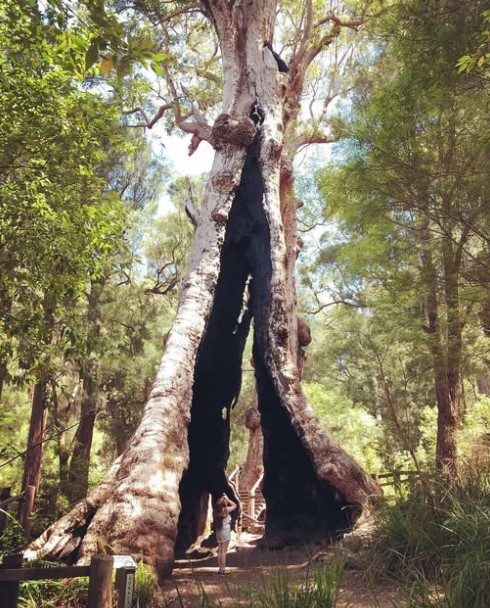
The Name: The Tingle Short Course gets its’ name from the mighty Tingle trees that are synonymous with the Great Southern. Tingle trees are known for their large girth rather than height, but still typically grow to heights of 45 meters, with their bases heavily buttressed. They really are a sight!
Looking for the Karri Long Course Overview and Maps? Click Here >>
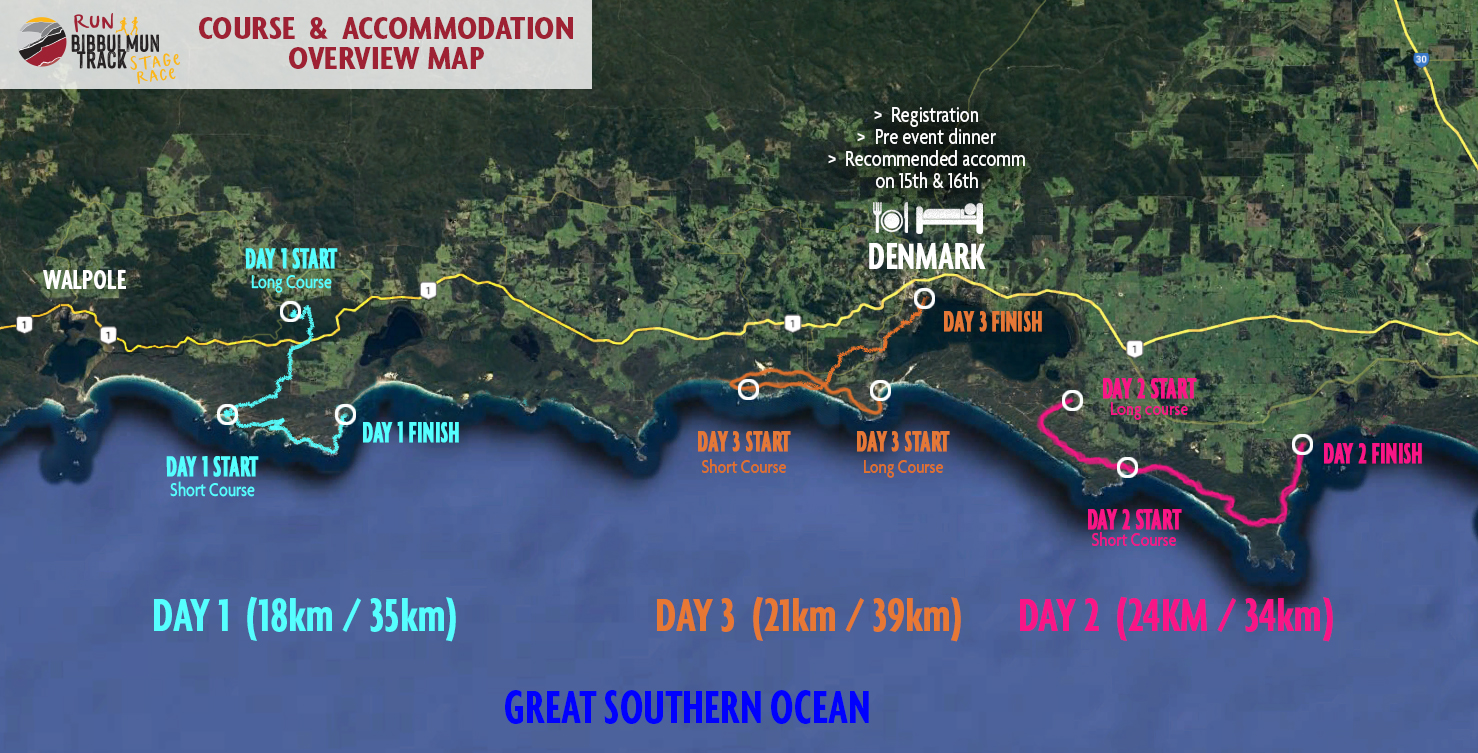
Tingle Short Course – Overview
| DAY / DATE | STAGE |
| DAY 1: Friday 14th November | STAGE 1: 17km – Conspicuous Cliffs to Peaceful Bay |
| DAY 2: Saturday 15th November | STAGE 2: 24km – Lowlands Beach to Cosy Corner |
| DAY 3: Sunday 16th November | STAGE 3: 21km – Greens Pool to central Denmark |
| 62km total |
Overview Course Map
Tingle Short Course – Stage Descriptions
Day 1 – 17km
Start location: Conspicuous Cliff Beach (on the sand).
Finish location: Peaceful Bay Playground, opposite the corner of Peaceful Bay Rd and Rame head Rd.
Length & elevation up / down: 17.8km. 315m up / 330m down
Race start time: 8:30am
Water points:
- WP2: 11km pt at the end of Gap Tk on the beach
Tingle runners start on the awe inspiring Conspicuous Beach, surrounded by steep dunes and cliffs and facing the wild southern ocean… it is a breathtaking start line!
Once under way the course joins the Bibbulmun Track as it climbs up and away from the beach and across the cliff tops providing views in all directions. The course soon diverts off the Bibbulmun Track for a spectacular adventure run along the wild and un-touched coastline, along the beaches and around rocky headlands above the high tide line to water point 1 at the 11km mark. Soon after the water point the course resumes along the Bibbulmun Track as it winds around Rame Head before turning north for the calmer waters of Peaceful Bay.
Leave the beach and then it’s a short stretch on the footpath to the finish line at the Recreation Reserve. Day 1 done!
NOTE: we’ve made a few changes compared to 2024 so that there is a little less sand running, and fewer deviations from the Bibbulmun Track – meaning the self navigation and route finding will be way easier 🙂
Day 2 – 24km
Start location: Lowlands Beach car park. Start is at the very end of the road.
Finish location: Cosy Corner. At the end of Cosy Corner Rd
Length & elevation up / down: 24km. 520m up / 520m down
Race start time: 8:30am
Water points:
- WP2: 17km pt at the Shelly Beach Road crossing
Day 2 starts at the impressive Lowlands Beach car park that offers yet more spectacular views of the south coast. The Tingle course follows the Bibbulmun Track all the way to the finish (so no self navigation needed!) as it passes through some of the more remote sections of the wildly beautiful West Cape Howe National Park.
Commencing with a long and gradual climb through the heathland you’ll soon capture views inland to the Porongurup Ranges and the Stirling Ranges in the distance. The trail is lined with plenty of wild flowers and some magnificent Banksias whilst the views open up to West Cape Howe itself and then Shelly Beach, Mutton Bird Island and the Torndirrup Peninsula near Albany.
After taking in the views you’ll enjoy a fast flowing descent before arriving at picturesque Cosy Corner and the finish of Day 2. Well done.
Day 3 – 21km
Start location: Greens Pool (on the beach) at the end of William Bay Road.
Finish location: The Footy Ground at MacLean Park, Brazier St – in Denmark.
Length & elevation up / down: 21.2km. 500m up / 500m down
Race start time: 8:30am
Water points:
- WP3: 6km pt at Lights Beach car park (again)
- WP4: 14km Ocean Beach Road crossing
The final day commences on the sand at the world renowned Greens Pool, where the turquoise water and rounded granite rocks have made some beautiful natural rock pools and swim enclosures.
Once under way you’ll pass equally popular Elephant Rocks and continue along the Bibbulmun Track past Madfish Bay to Lights Beach and the first water-point at the 6km pt. After Lights Beach, the Bib Track changes character and heads inland, climbing up through dense Karri and Tingle forests and over the course’s highest point at Mt Hallowell (294m!). From the summit it is downhill (nearly) the whole way as the course descends the mount, and weaves through a few streets and hidden pathways beside Wilson Inlet and into the finish line in central Denmark.
Well done – you’ve just finished the Run Bibbulmun Track Stage Run!
Following the trail
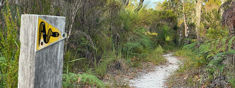
The course will NOT BE MARKED. Competitors must navigate their own way along the course by following the GPS route downloaded to their phones whilst racing (GPS route and clear instructions how to use it will be provided).
Having said that, the vast majority of the course is along the Bibbulmun Track which is very well marked, and where the race course deviates away from the Bib track it will be easy to follow using your phone and some common sense.
It is the runner’s responsibility to ensure you follow the designated race route. This is the way we’ve conducted the event for the last 3 years and no one has had major issues having found the self navigation quite straight forward.
Trail textures and terrain
The course provides a remarkable variety of terrain from start to finish, from sandy trails winding through the dunes to rock hopping around the coastline – and everything in between.
Nearly the entire course is ALL SINGLE TRACK. If you are not running on single track then you are on firm sandy beaches or, on occasion, 4WD tracks with just the a very small amount of asphalt across the 3 days.
There is a moderate amount of sand on the course but on the whole the sand is A LOT FIRMER than the sand you may have run on if you have done the Margaret River Ultra Marathon course. There are some sections of soft sand on beaches, but the sand on the single track is very runnable and provides for good going.
Waterpoints and On-Course Support
Waterpoints will be established at varying points along each day’s course, but may be up to 10-15km apart due to the inaccessibility of the terrain.
Waterpoints will provide basic foods for runners like fruit cake, lollies, fruit and plenty of Skratch Nutrition drinks, chews and bars.
Support crews can provide physical assistance and support at the designated waterpoints (only). No other assistance (other than verbal encouragement!) can be provided between checkpoints.
There will be very few, if any, marshals mid-way along each leg so runners must be self-sufficient and able to run independently between each waterpoint. We will, however, be supervising all sections of the course. We will have sweep runners to ensure runner safety.
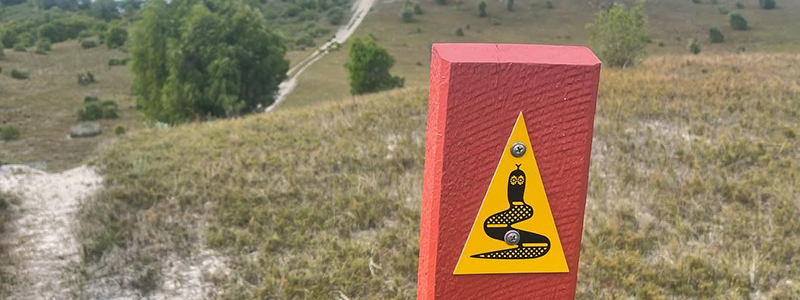
The Bibbulmun Track

The Run Bibbulmun Track Stage Run follows large sections of the Bibbulmun Track between Walpole and Cosy Corner. The Bibbulmun Track as a whole is one of the world’s great long distance walk trails, stretching 1000km from Kalamunda in the Perth Hills all the way through to Albany, winding through the heart of the scenic South West of Western Australia.
The course does not follow the track exclusively, as we deviate off the official route on a number of occasions where we think there is a more scenic option.
We are proud to be Bronze Level sponsors of the Bibbulmun Track Foundation. We strongly encourage entrants to also make a donation to help preserve the track and it’s surroundings.
Points of interest on the Bibbulmun Track